Key Points
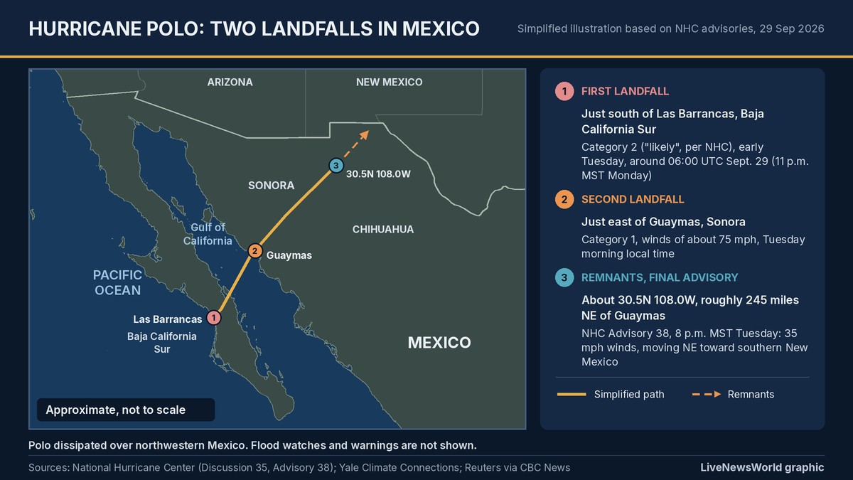
- Polo struck Baja California Sur near Las Barrancas as a Category 2 hurricane late Monday local time (early Tuesday UTC), then came ashore again near Guaymas, Sonora, as a Category 1.
- The National Hurricane Center’s final advisory, No. 38 at 8 p.m. MST Tuesday, placed Polo’s remnants about 245 miles northeast of Guaymas with 35 mph winds.
- Baja California Sur’s governor reported no deaths; flooded roads and fallen palm trees and utility poles were the main early damage.
- Polo’s remnants brought flash flooding and evacuations to southern New Mexico, including near the McLeod Dam, and the rain threat has since shifted east into the Plains and Central Texas.
Hurricane Polo is gone, but its rain is still causing trouble. The storm made two landfalls in Mexico between late Monday and Tuesday local time. It hit the Baja California peninsula first, then the mainland in Sonora, before breaking apart over the mountains of northwestern Mexico. Its leftover moisture then flooded parts of the US Southwest, forcing evacuations in New Mexico, and is now moving across the Plains.
Where Hurricane Polo made landfall in Mexico
The first Hurricane Polo Mexico landfall came at about 11 p.m. MST on Monday, Sept. 28, local time (06:00 UTC Tuesday). The center crossed the west coast of Baja California Sur just south of the small town of Las Barrancas. In its landfall discussion, the National Hurricane Center said Polo was “likely” a Category 2 hurricane at that moment. It put maximum winds at 90 to 95 knots, or about 105 to 110 mph, while noting some uncertainty about the exact intensity.
Mexico’s National Meteorological Service (SMN) also reported a Category 2 landfall near Las Barrancas, in Comondú municipality. It gave sustained winds of 175 km/h, Proceso reported. The NHC had rated Polo a Category 3 in its last full advisory before landfall, and some early reports described a Category 3 landfall. However, the NHC’s assessment of the landfall itself is Category 2.
Yale Climate Connections put the landfall at 110 mph with a central pressure of 965 millibars. It called Polo tied for the fourth-strongest hurricane on record to hit the Baja peninsula.
Polo then crossed the peninsula and moved over the Gulf of California. By then, dry air, wind shear and rugged terrain had already damaged its structure. It made a second landfall a little east of the port city of Guaymas, Sonora, on Tuesday morning local time. It was a Category 1 hurricane with winds of about 75 mph, according to the NHC and Yale Climate Connections.
Damage and safety in Baja and Sonora
On Baja, Polo flooded crossings and toppled palm trees and utility poles. Police also had to block flooded roads, CBC reported. Baja California Sur Gov. Víctor Manuel Castro said no deaths had been reported. “We expected it to be stronger, but thank God it wasn’t so disastrous,” resident Bertha Lopez told Reuters.
In Sonora, the NHC had warned that heavy rain could cause life-threatening flooding and mudslides, especially in steep terrain. It forecast 4 to 6 inches (10 to 15 centimeters) of rain across southern and central Sonora. Isolated totals could reach 8 inches (20 centimeters). Damage assessments in both states were still preliminary as of Wednesday.
Polo dissipates: what NHC Advisory 38 says
At 8 p.m. MST Tuesday (03:00 UTC Wednesday), the NHC issued its last public advisory on the storm. Its headline read “Polo dissipates over northwestern Mexico.” The key details:
- Location: about 30.5 degrees north, 108.0 degrees west, roughly 245 miles (395 kilometers) northeast of Guaymas.
- Winds: maximum sustained winds near 35 mph (55 km/h).
- Movement: northeast at about 23 mph (37 km/h).
- Pressure: 996 millibars.
- Warnings: no coastal watches or warnings in effect; a wind advisory remained for parts of southern New Mexico and far western Texas.
In its final discussion, the NHC said the remnants were “still producing areas of heavy rain and gusty winds.” That applied to northwestern Mexico and the southwestern United States. It added that the moisture “will likely produce heavy rainfall and flooding across the Southwest U.S. and the Southern High Plains tonight and Wednesday morning.”
Flooding and evacuations in the US Southwest
The NHC said Polo’s leftover energy was expected to merge with a strong low-pressure system digging into the Four Corners region, spreading tropical moisture across Arizona, New Mexico and Texas. The result was days of flash flooding. The Washington Post counted nearly 100 local storm reports related to flooding in the Southwest since Monday.
The most serious scare came in southern New Mexico. On Tuesday, Doña Ana County urged residents of Hatch, Placitas, Salem, Garfield and Rincon to evacuate amid a flash flood emergency, as the McLeod Dam, known locally as the Garfield dam, showed signs of potential failure, the Albuquerque Journal reported. A county spokesperson said Tuesday evening that “a very small piping failure” had been mitigated and that, at that point, no water was exiting the dam. By 11 p.m. Tuesday, only Rincon remained under an evacuation notice, “due to the dangers of standing floodwaters,” the county said.
In Arizona, rescuers pulled people from floodwaters on consecutive days. A Maricopa County Sheriff’s Office helicopter team rescued a driver clinging to his overturned truck in Tonopah, west of Phoenix, on Tuesday, weather.com reported. On Monday night, Mohave County deputies rescued a family of four from an RV swamped by floodwaters near Lake Havasu City.
Where the rain goes next
By early Wednesday, Polo’s remnants were racing across the Texas and Oklahoma panhandles on a more easterly track than first forecast, the Post reported. Parts of Kansas, Nebraska, Iowa, Illinois and Missouri could see 2 to 4 inches of rain and flooding on Wednesday, with 4 to 8 inches possible in Central Texas into Thursday.
As of Wednesday afternoon Mountain time, National Weather Service offices had flood watches posted for parts of Colorado, Kansas, Missouri, Nebraska, New Mexico, Oklahoma and Texas, and flood warnings in parts of Arizona, Kansas, Missouri, New Mexico and Texas. Alerts are changing quickly, so residents should check their local NWS office for the latest information.
If you are in a warned area, avoid driving through flooded roads and low-water crossings. Move to higher ground if water begins rising. Flash flooding in desert washes can arrive with little warning, even when it is not raining where you are.
Not the same as Nolo or Rachel
Polo is separate from two other storms in the news. Hurricane Rachel had 85 mph winds about 220 miles southwest of Cabo Corrientes, Mexico, as of the NHC’s 8 a.m. MST Wednesday advisory. Mexico has discontinued all coastal watches and warnings, and the NHC expects Rachel to pass south of the Baja California peninsula through Thursday, possibly as a major hurricane. In the Central Pacific, Nolo has weakened to a tropical storm west of Hawaii.
What happens next
The NHC has stopped issuing advisories on Polo, so forecasts now come from the Weather Prediction Center and local NWS offices. The main risk from its remnants is flooding, not wind, as the rain moves from the Southwest into the Plains and Texas. For ongoing US weather coverage, follow our US weather live hub.